Maps & Directions
Google Maps and other mobile phone-based GPS applications can be used to help you navigate within the Cemetery.
If you are in a vehicle, you can enter Albany Rural Cemetery during visiting hours via either of the two gated-entrances, the Main Gate on Cemetery Avenue off Broadway (Route 32) in Menands, and the South Gate off Menand Road (Route 378) at the intersection of Van Rensselaer Boulevard (Route 377).
Both vehicle gates are open daily from 7:30 AM to 7:00 PM during daylight savings time. During winter, the gates close at 4:30 PM
In addition, those who are walking or riding bicycles can enter via the Beth Emmeth Cemetery through Schuyler Road or via the gate located on Spring Street.
The Cemetery is accessible by public transportation. The main gate (Broadway/Route 32) is served by Capital District Transit Authority (CDTA) Bus #22.
Bus Rapid Transit (BRT) Blue Line buses #922 and #923. The South Gate (Menand Road/Route 378) is accessible by #182. All buses are equipped with bicycle racks
.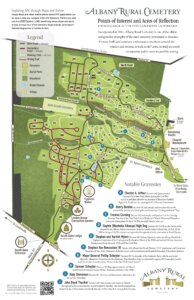

For first time visitors, entering by the South Gate makes navigation through the Cemetery a bit easier at the outset. If you enter the Cemetery via the South Gate, you will be on Linden Avenue (which runs south to north). Three major west-to-east roads run off of Linden down the hill toward the Hudson River. They are in sequence, South Ridge Road, Middle Ridge Road, and North Ridge Road. Taking any one of these three west-to-east roads will take you down the hill to Cemetery Avenue and then out to the Main Gate. Due to significant storm damage, Middle Ridge Road is closed to automobile traffic. If you come in via Broadway and Cemetery Avenue to the Main Gate, you will encounter the Main Office and the Chapel Mausoleum.
Signs are located off Linden directing visitors to the memorial for President Chester A. Arthur, as well as to the main office. Coming up from Cemetery Avenue on South Ridge Road, signs indicate the direction to the South Gate.

Albany Rural Cemetery is an incredible historical resource, as well as a treasure of natural and man-made beauty. It is the ideal spot for walking, jogging, bicycling, roller-blading, or taking a leisurely and scenic drive. The natural topology of the area helps to define the roadways in ARC. The ravine north of North Ridge Road, as well as the ravine between North Ridge Road and Middle Ridge Road, and the ravine between Middle Ridge Road and South Ridge Road are beautiful areas to explore in both summer and winter. The Kromme Kill flows between North and Middle Ridge Roads, while the Moordanaers Kill flows between Middle Ridge Road and South Ridge Roads. The ravines with these streams, as well as some of the minor roads and pathways are more rustic areas. They remain unplowed during winter, but are beautiful places for hiking during warmer months or for cross country skiing or snow-shoeing in the winter.
Note that each area of the Cemetery that is bounded by a road has a Section Number designation from 1 to 232. Section numbers are on a shield-shaped sign that is placed either on a short metal pole or on a tree near the roadway. See photo of Section Number 18.
The current maps, as well as the historical maps reflect these Section Numbers, which have remained unchanged since the original design of the Cemetery. Section Numbers allow you to reference specific historical personages or family gravesites. Note that the burial plots within each section are also given a unique Lot Number. Check in the Cemetery office to view the Section/Lot Number for any specific burial, or use the Grave Search function on our home page, to find the Section and Lot Numbers. The Cemetery office has maps that show the location of each lot within each of the Section Numbers. In the historical maps section, you can look at the 1912 Map for specific lot numbers for burials through that period. The main office is the only location with an updated map, including ALL Section/Lot numbers. To find the actual lot number and section location of a recent burial, you will need to have the staff in the Cemetery office look it up in the lot book.

The cemetery has many other roads, both paved and gravel running throughout its 467 acres, providing access to almost all areas of the Cemetery. If you examine the maps in the historical section of the web site you will see where the present and also former roadways connected together. Many of the old roadways now have grass growing on them and are chained off to car traffic. These roads and pathways provide a very interesting trip back into the history of ARC.
Visitors can also use the ARCE Explorer http://www.albany.edu/arce, a GIS-based map to take a virtual tour of the Cemetery, locate burials, and explore themed biographies of notable burials.